Related Topics
Philadelphia's River Region
A concentration of articles around the rivers and wetland in and around Philadelphia, Pennsylvania.
Bystanders to the Revolution
It wasn't heroic to everyone.
Historical Preservation
The 20% federal tax credit for historic preservation is said to have been the special pet of Senator Lugar of Indiana. Much of the recent transformation of Philadelphia's downtown is attributed to this incentive.
City of Rivers and Rivulets
Philadelphia has always been defined by the waters that surround it.
Central Pennsylvania
"Alabama in-between," snickered James Carville, "Philadelphia, Pittsburgh, and Alabama in-between."
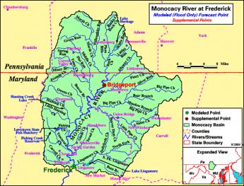
Monocacy Creek and Monocacy River
|
| Monocacy River |
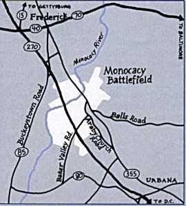
Monocacy sounds like a Greek word for some form of government, but is in fact a Shawnee Indian term, meaning "crooked river". It might well be spelled as the Indians pronounced it, Monnockkesey. Confusion for history lovers is made worse by the existence of a Monocacy Creek about twenty miles long, flowing into the Lehigh River at Bethlehem. But there is a second stream, the Monocacy River, flowing about sixty miles south from Gettysburg, through the town of Frederick, Maryland, eventually merging with the Potomac River a few miles south of Harper's Ferry. Both forms of Monocacy do flow-- but do not connect-- along the base of the first mountain range of the Alleghenies, on its Eastern side. Pennsylvanians refer to this ridge as the Blue Mountain because looking westward it can be hazily seen across the plain from a great distance. In Maryland, it is called the South Mountain. In the early part of the Civil War, General Lee attempted to attack Washington DC from the rear by striking through several gaps (particularly "Fox's Gap") in that mountain. The Philadelphian General George McClellan uncharacteristically surprised him by getting masses of Federal troops through the mountain gaps before Lee could reach and fortify them from West Virginia. Although McClellan did intercept some of Lee's orders, it is now questioned whether this affected the outcome. The culminating result was what the Union side continues to call the Battle of Antietam Creek, but the former Confederates persist in naming the Battle of Sharpsburg. Antietam Creek is one of those many creeks which flow along either side of the long mountain range, fed by runoff rainwater from the ridge, and therefore has steep embankments. Regardless of the nomenclature quarrel, the main point is that both of these placenames refer to the west side of the mountain gap, putting Lee at a disadvantage for an attacker. He got there first, but he did not get there first with enough force to dominate the passes.
|
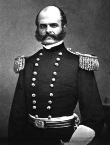
| General Ambrose Everett Burnside |
A horrendous slaughter of Federal troops took place when General Burnside was ordered by McClellan to get his troops across Antietam Creek immediately, and Burnside chose frontal attacks over a narrow stone bridge crossing the Antietam as the way to get there. Because of the creek's flow along the base of the mountain, once the bridge was crossed under constant sniper fire, the troops faced a sheer embankment which had to be climbed into the face of 500 Confederate sharpshooters shooting down from the top. Burnside and the Federal troops finally did accomplish this suicide mission after four hours of trying, mostly because the Confederate sharpshooters ran out of ammunition. At the end of that day, 23,000 troops on both sides were casualties. Toward the end of the war, similar casualties would be sustained fifty miles north at Gettysburg PA, along a branch of the Monocacy on the east side of the ridge. The two Monocacy streams, Creek and River, are entirely distinct but a natural source of confusion.
|
| Monocacy River Map |
It would seem a pity, however, to succumb to a fit of tidiness and change the name of either stream. The Shawnees were once the most important Indian tribe in this region, and at various times have achieved dominance over regions from the Delaware River to Oklahoma. As a major component of the Algonquin federation of tribes, they fought a losing battle with the Iroquois over a period now named the Sixty Years War, eventually retreating from the Eastern Alleghenies to Ohio. Meanwhile, the Iroquois were destroyed by the consequences of the Revolutionary War, while eventually, the Shawnees retreated to reservation areas in Oklahoma. The Monocacy streams, both of them, represent a high-water mark of Shawnee influence. It would be sad to see the last few vestiges of their pre-eminence, even if only names on a map, destroyed by inadvertence or indifference.
Originally published: Tuesday, June 29, 2010; most-recently modified: Friday, May 24, 2019