Related Topics
City of Rivers and Rivulets
Philadelphia has always been defined by the waters that surround it.
Sights to See: The Outer Ring
There are many interesting places to visit in the exurban ring beyond Philadelphia, linked to the city by history rather than commerce.
Land Tour Around Delaware Bay
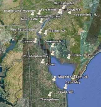 Start in Philadelphia, take two days to tour around Delaware Bay. Down the New Jersey side to Cape May, ferry over to Lewes, tour up to Dover and New Castle, visit Winterthur, Longwood Gardens, Brandywine Battlefield and art museum, then back to Philadelphia. Try it!
New Jersey (State of)
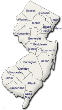 The Garden State really has two different states of mind. The motto is Liberty and Prosperity.
The Philadelphia Bay (1)
It's about sixty miles from Salem, New Jersey where the river takes an abrupt turn to the right, to Trenton, where the river takes an equally abrupt turn to the left. This is the area that could be called the Philadelphia Bay, a protected extension of Delaware Bay. Benjamin Franklin, who sailed down this bay on his many trips to Europe, noticed that it was not exactly a river, because the salt water seemed to invade it, whereas most big rivers have fresh water pushing out to sea. The true Delaware River comes down from the north and empties into Philadelphia Bay at Trenton. We now know that barrier islands begin out at sea every three hundred years or so, gradually move toward the shoreline, and pack themselves against the mainland about three hundred years later. Depending on circumstances, there are usually several sand reefs in various stages of development. Southern New Jersey is made up of a number of barrier islands packed together as they moved toward the mainland of Pennsylvania. The barrier islands actually have packed solid against the Pennsylvania coast, from Trenton to New Brunswick, closing off the ancient northern inlet to the bay. Barnegat Bay is a more recent variant of the same process, running parallel to the more ancient Philadelphia Bay. Since its northern inlet is almost closed at Barnegat Inlet, this seems to be a regular phenomenon of Atlantic barrier island development. Lower Delaware Bay, from Salem to Cape May, appears to have a different history, probably a volcanic split.
|
||
| Joshua Fisher's 1778 Map of Delaware Bay |
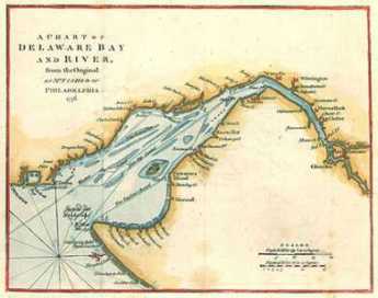
In the days of sail, Philadelphia Bay was the main artery of internal commerce. When the Delaware-Chesapeake canal was dug in 1829, it extended the inland waterway from Trenton to Norfolk VA. The earliest commerce took advantage of the tide and the bends in the "river" which was actually just the remnant of ocean between mainland Pennsylvania and the former barrier island of New Jersey. It had tides, but not much in the way of waves. Flatboats filled with Garden State produce would be carried up and across the river by the incoming tide, and down and across the river by the outgoing tide. When ships, particularly steamships, came along, this was the way to carry goods of all sorts up and down the Bay. At Odessa, it's only five miles between the Chesapeake and Delaware Bays, so even prior to the old Delaware-Chesapeake Canal sailing commerce was natural from Trenton to Norfolk, Virginia, and all points in between. The next step was building canals, up to the Raritan to New York Bay, and even up the "Main Line" west to Pittsburgh and beyond. The war of 1812 blocked off ocean shipping, and then another canal carried anthracite to Philadelphia, emptying at Bristol, briefly enriching Bristol, but then leaving it reduced to its present vestigial state when the tracks of the Pennsylvania Railroad cut it off. After canals came railroad tracks, usually following the path of the canals, making smoke and noise, constructing a dangerous, impenetrable barrier between the land and the water beside it. Superhighways do the same thing, replacing soot with gasoline fumes. There's a river out there somewhere, but you can't get to it. It now takes a twenty story high rise to give you a river view; even that is best seen on Sunday when lessened traffic reduces gasoline haze.
It's really hard to imagine that main attractions to living on the river once included not merely the view and the transportation, but also wonderful fishing and hunting among the bullrushes. Down around the Delaware Chesapeake Canal, Blackbeard the Pirate used to hide his ship and merry men in the shallow marshes among the mud islands. There's a reminder of it as you speed along the elevated multi-lane highway, or maybe it's just another reminder of political correctness. If you know the way well enough to take your eye away from the traffic pattern, off to the right is a directional sign pointing to the little cove where pirates used to convene. It says, "Blackbird".
Originally published: Monday, June 26, 2006; most-recently modified: Friday, May 24, 2019