Related Topics
Quakers: William Penn
Although Ben Franklin gets more ink lately, William Penn deserves at least equal rank among the most remarkable men who ever lived.
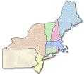
On the Making of Boundaries: PA/NY
|
| North East US |
Ask yourself if you can think of any boundary of any country in Europe or Asia -- which is a straight line. There aren't any, at least to speak of, but in America lots of States have straight-line borders. In every place except America (and later, Africa and the Near East) borders were always "natural" borders, which for the most part meant they followed either rivers or (what is essentially the same thing) the ridges of mountains, forming the edges of river basin drainage. You can see why this is so; it keeps cattle and children from wandering off the property and lessens the chance that one group will pollute the headwaters of someone else's water supply. Rivers and mountain ridges make natural defense barriers, and for the most part, they don't move around and start arguments.
Now, ask yourself what you would do if you were King and somebody handed you a piece of parchment drawn with the roughest of maps, asking you to give away pieces of some unexplored continent that took two dangerous months of travel to get to. In the Sixteenth Century, no one knew where the American mountains and rivers ran. And as a matter of fact, the north-to-south coast of North America was considerably tilted to the East, so most coastal rivers ran in a Northerly direction instead of due West. But who knew, for certain? So, the tendency was to make land grants from the mouth of one river to the mouth of another one, with their Northern, Southern and Western boundaries kind of vague. In the case of Pennsylvania, the Eastern border was the West bank of the Delaware River, which was easy enough, and the King gave New York A Strip of land Following the Hudson River. The lucky thing is that the Mohawk River turns Sharply left at Albany the head of the Hudson, and then this extension of the Hudson really does run straight West. So it was easy enough to agree that the Northern border of Pennsylvania would be a straight line a hundred or so miles to the south of the Mohawk, more or less parallel to it, through a dense forest no one cared much about. This arrangement had the beauty of cutting off Connecticut's Claims created by haphazard wording of the grant from Charles II. This satisfied everybody for eighty years until vacant land became scarce and someone in Connecticut got the bright idea of resurrecting the King's old "unnatural" boundaries as two pieces on either side of New York. As a matter of fact, Connecticut got the idea that the Hamptons on Long Island ought to belong to them, too. We shot a few hundred people and then that, too, was settled. As a later addendum, the Penn proprietorship wanted guaranteed access to the Great Lakes, so a little piece along Lake Erie was Sold to them in 1792 for $151,640, thus completing the present boundaries of northern and eastern Pennsylvania.
To the south, although fewer people got scalped and/or shot, dealing with Lord Baltimore and his descendants proved to be a far less agreeable experience.
Originally published: Monday, June 26, 2006; most-recently modified: Wednesday, May 29, 2019